IgeoNews
Both, meridians and parallels, form the geographic coordinate system based on latitude and longitude
Meridians are the terrestrial geoid highs semicircles passing through the poles, imaginary lines used to determine the microseconds. By extension, are also the maximum semicircles passing through the poles of any reference sphere or spheroid. All observers located on the same meridian are at the same time, in the lighted half of Earth, the Sun at the top of its course when the Sun is at the top of the course indicating noon.
By resolution, adopted at an international conference held in 1884 in Washington, and sponsored by then President of the United States, attended by delegates from 25 countries, the “reference meridian “, from which lengths are measured , i.e. , which is considered the “longitude 0 °”, is the Greenwich meridian, so called because it passes through the ancient observatory in Greenwich.
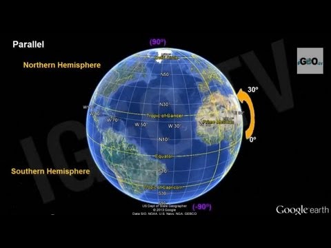
Circle formed by the intersection of land area with an imaginary plane perpendicular to the axis of rotation of the Earth is called parallel.
On the parallels, and from the Greenwich meridian, meridian that is taken as origin, measure the length, the circle is expressed in degrees, which may be East or West, depending on the direction of measurement of the same. Unlike meridians, parallels are not as great circles, except Equator, do not contain the center of the Earth.
The angle ( with vertex at the center of the Earth ) on any plane parallel and meridian for the equator is called latitude and is the same for all points of the parallel , which discriminates between North and South latitude, according to hemisphere.
There are five main striking parallels or corresponding to a particular position of the Earth in its orbit around the sun, and therefore receives a particular name:
-Arctic Circle (latitude 66 ° 33 ‘ N = 90 º – 23 º 27’).
-Tropic of Cancer (latitude 23 ° 27 ‘ N). It further north latitude at which the sun reaches its zenith. This occurs at the June solstice.
– Equator (latitude 0 °). In Equator the Sun culminates at the zenith on the equinox of spring and autumn.
– Tropic of Capricorn (latitude 23 ° 27 ‘ S). Is the parallel further south where the sun reaches the zenith. This occurs at the December solstice.
– Antarctic Circle (latitude 66 ° 33 ‘ S).
http://igeo.tv/
Watch Video 3D Earth Globe:
https://www.youtube.com/watch?v=Hrf-BB6cipM
Source


Will u plz upload another video we cannot understand and something wrong over here
The so much
rotation direction is wrong…its west to east not east to west…
rotation is from West to East……. in the video the earth movement is correct but the written fact is wrong..!
Rotation is correctly represented, the earth rotation is west to east, if looked from northern hemisphere and from east to west, if observed from the southern hemisphere. Just like in the video presentation. Very good and informative video. Thank you for sharing it!
Rotation is from West to East
I think it's wrong
Thanks.
Very nice
this video helped in my geography exam
You can fool some of the people all of the time, and all of the people some of the time, but you cannot fool all of the people all of the time! You are losing your grip on thinking individuals! Thank God
I am in the 4th grade and I am studying for my test
nice
Thanks sir sk
how tomake video like this graphical representation of earth plz
it helped me in my exam thx
The philiphens is near at the equater
Gracias…
thanks IgeoNews !
Sadly this was one of the most insightful videos I have seen in a really long time. Just shows how ignorant I was to most of this information.
Awesome video….thnx for ur hardwork for making
will you please upload a vedio in which Instruct how can we draw a longitude on a plane paper by geometrical method. …???????
very good application
Why the freakin music ! !!
Nice video
Like the music who is it?
Im student it is v good for me bro?
Please note there were few mistakes, the Earth rotates from west to east or counter-clockwise.
Great propagandist video with nice cartoons.
Hint: maybe post a real photo of earth from 'up there'.
Oh wait, there aren't any real earth photos, yet (in my 60 year lifetime). How do we KNOW the earth isn't flat with no NASA photos nor Satellite 24/7 videos of ball-earth from 'space'?
awsm
good music
Thank you so much for this awesome upload! !I really
you deserve all the likes from facebook and all the shares from twit
by the way it's equator
It's flat
The earth is not a spinning globe.
Evidence: Anti meridian line does not exist. We know one meridian line used for timing reference (GMT), crosses England and Ghana. Then, where is its opposite? it just exist on drawn globe picture, it does not exist for real.
thanks for a very interesting videos about the earth